A walking tour map on your phone always looks the same. A line, fourteen pins, and underneath it “7.7 km · 2 h 1 min”. What that means only becomes clear once you are walking. In Lubeck, for instance, when you have ticked off two stops at the Holstentor and realise the cathedral is a 22-minute walk away.
That is why, since 27 September 2026, Mapped by Stubbs has a step before the first step: the 3D flyover. Stubbs flies over your whole walking tour first, as a 3D walking tour seen from above, lands at every spot and asks whether it should stay in.
What is the 3D flyover? The 3D flyover is an animated preview of your walking tour in Mapped by Stubbs. A camera follows the planned route over a 3D city model and stops at every spot. You see photos, opening hours and, where available, ratings and decide: keep it or cut it. Then the app recalculates the route. Free, no account needed.
A 3D walking tour of Lubeck: what the flight looks like
A real example works best. The ready-made tour on our Lubeck walking tour page has 14 spots, 7.7 kilometres and 2 hours 1 minute of walking. The images below come from exactly that flyover, recorded in a browser at phone size.
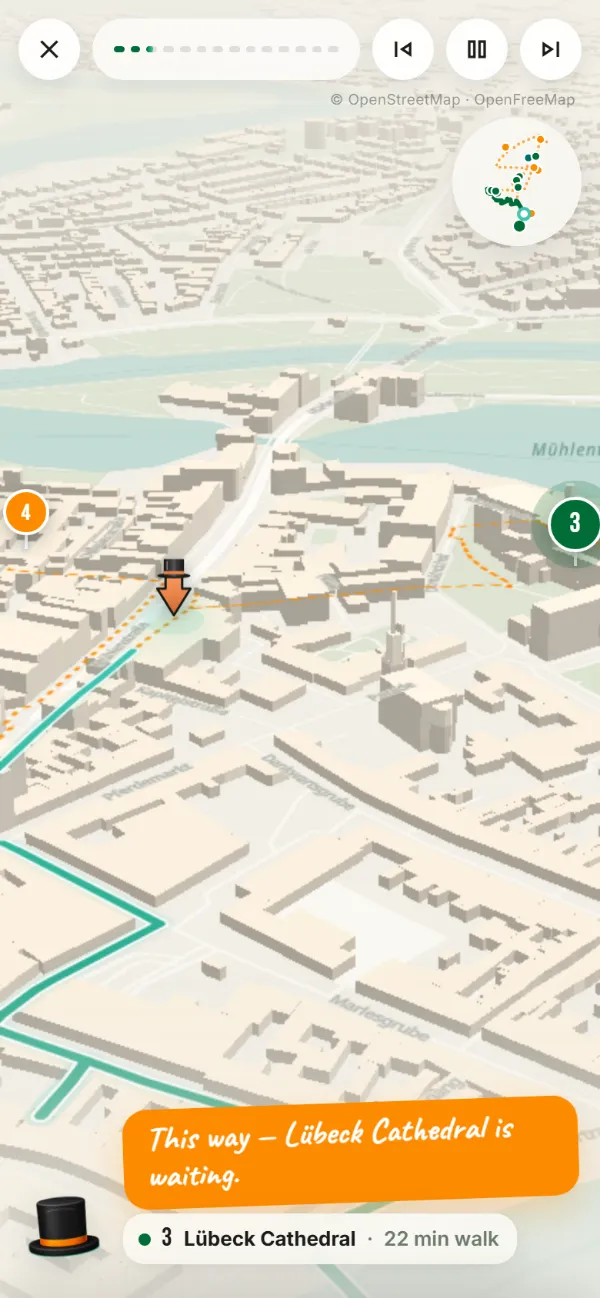
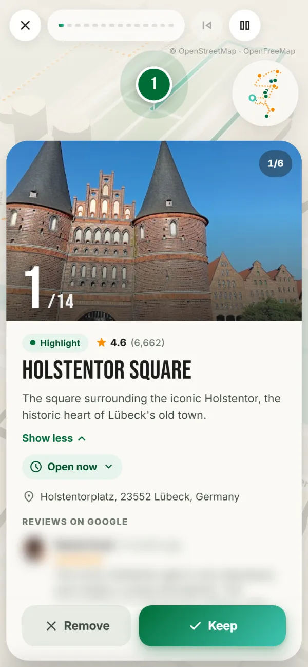
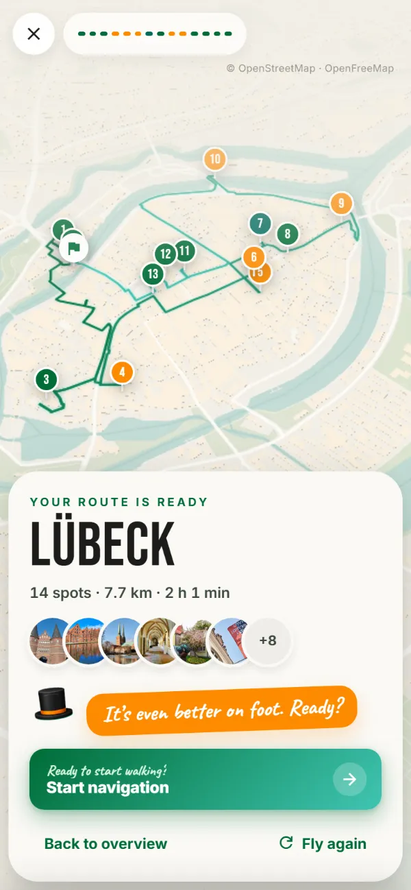
The flight runs in four phases:
- Opening. The loop draws itself across the city as an orange dotted trail, and the pins pop up where the line reaches them. You can already tell whether the tour is a compact circle or a long stretch.
- Flight. A chase camera flies along the real streets at an angle from above. Stubbs, the top hat, pulls the line along, with the next stop and the minutes on foot shown at the bottom. A small map in the top right shows where you are in the loop.
- Landing. At each spot the camera turns in and circles slowly, then the spot card builds up.
- Finale. The camera rises to an overview of the whole loop. If you cut spots, the app recalculates the route and draws the new loop.
Why we show the route first
A list of sights tells you what there is. It does not tell you what it feels like to walk all of it. That is where most self-guided walking tours go wrong: rarely in the selection, almost always in the distance between the stops.
In the Lubeck example the first two stops, Holstentor Square and the Salzspeicher salt warehouses, sit practically side by side. A 4-minute walk. Then come 22 minutes to Lubeck Cathedral at the southern end of the old town island. On a flat map the cathedral is one pin among many. In the flyover you travel that stretch, the rows of houses slide past, and you notice: this is a proper detour.
If you only have two hours that day, you might cut the cathedral. Or you cut two spots in the north instead, because the cathedral is exactly what you came to Lubeck for. Either is fine. The only mistake is finding out at the salt warehouses, with tired feet and a café in sight.
What you see at every stop
The spot card in the flyover shows the same details as the regular preview, without you having to open them. Expanded by default:
- Photos, up to six per place, to swipe through
- Opening hours with “Open now” or “Closed” and the weekly schedule, today highlighted
- Address, category and rating: highlight, recommendation, insider tip or café, plus, where available, the stars from Google
- up to three Google reviews, where the place has any, and for insider spots Stubbs' own tip on why the place is worth it
The opening hours are the underrated part. A museum that is closed on Mondays is better cut now than discovered at a locked door. In our test flight the first stop, Holstentor Square, showed a green “Open now”, which is easy for a square. The Holstentor Museum inside the gate had already closed. It was Sunday evening.

Keep it or cut it, before you set off
Every spot card has two buttons: Keep and Remove. After “Remove”, Stubbs flies straight on to the next stop, and for five seconds you can undo it. Changed your mind later? “Previous spot” jumps back to the last place, even in mid-flight.
The route is only recalculated at the end, once for all your changes. If you cut three spots, you should not have to wait for a new route three times. There is one catch: after cutting, the order can change, because the app looks for the shortest loop through the remaining spots. That is why the finale shows you the new loop before you start.
From there, “Start navigation” gets you going. For live navigation on the move, with turn-by-turn directions and voice guidance, you need the free Android app. An iPhone app is in the works, and planning and the flyover already run on an iPhone in the browser.
Do other city guide apps do this?
Which apps preview a walking tour in 3D? Some pieces exist, but we have not found the combination anywhere. Google Maps shows a route in 3D with Immersive View for routes in selected major cities. Komoot turns an activity you have already finished into a flyover video. Neither flies over a curated walking tour before you start and lets you decide at every stop.
Before we released the flyover, we wanted to know whether we were reinventing something that already existed. Here is what we found, as of September 2026:
| Product | What you see | When | Decide per stop |
|---|---|---|---|
| Mapped by Stubbs, 3D flyover | Curated walking tour as a 3D flight, stopping at every spot | before you go | yes |
| Google Maps, Immersive View for routes | A route from A to B in 3D, launched in 2023 in 15 major cities such as London and Paris, none in Germany | before you go | no |
| Komoot, Flyover | A short video of the route over satellite imagery | after the tour | no |
| Komoot, 3D map | Terrain and elevation while planning, Premium, desktop browser only | while planning | no |
| izi.travel, SmartGuide, GetYourGuide | Audio tours or booking; we found no 3D route preview | n/a | no |
The difference is timing. Komoot's flyover is a keepsake of a tour you have already done, built for hiking and cycling routes. Google shows you a route you picked yourself. The flyover sits in between: Stubbs made the selection, you make the final call, and you make it before you leave. How the apps compare otherwise is covered in our city guide app comparison.
Is it a virtual walking tour?
Partly. People searching for a virtual walking tour often mean a 360-degree tour that lets you visit a city from the sofa. The flyover is not that. The city deliberately appears as a calm, ivory-coloured architectural model without photorealism, and only your route has colour. It is not meant to replace the trip. It is meant to tell you whether this loop is the right one.
It still works well from the sofa. Create tomorrow's tour the evening before, fly over it once, cut two spots, done. In the morning, all that is left is to start.
How to start the 3D flyover
- Open a city page such as Lubeck, Heidelberg or Bamberg and tap “Start this tour”. For any other city, enter the city and a starting point on the start page.
- In the preview, tap “3D flyover” at the bottom left of the map.
- At every spot: “Keep” or “Remove”. On a computer the space bar pauses and the arrow keys go forward and back.
- In the finale, tap “Start navigation”, or go back to the overview if you want to change more.
It costs nothing, needs no account and runs in the browser on iPhone, Android and desktop.
Where the flyover reaches its limits
The buildings are blocks built from OpenStreetMap data, not photographed facades. That is intentional, because a calm model keeps the route readable. It also means you recognise the Holstentor in the model by its two round towers, not by its brickwork. The spot's own building is not highlighted; the camera points at the pin. And in very dense old towns, pins sometimes overlap.
On older phones the 3D view is demanding. If the frame rate drops below about 25 frames per second, the flyover lowers its resolution by itself. If it still stutters, skip ahead to the next spot.
Frequently asked questions about the 3D flyover
Can I preview a walking tour in 3D before I go?
Yes. Create a tour or open a ready-made one on a city page, then tap “3D flyover” at the bottom left of the preview map. Stubbs flies the whole route before you take your first step.
Does the 3D flyover cost anything?
No. It is free, needs no account and runs in the browser and in the Android app.
Does the flyover work on an iPhone?
Yes, in the browser, with nothing to install. Live navigation on the move is currently in the Android app, and an iPhone app is in the works.
Which cities does the flyover work for?
Any city Stubbs creates a tour for. The 3D buildings come from OpenStreetMap, which has very good coverage in Europe. Where building heights are missing the model is flatter, but you still see the route and the spots.